Friday, May 20, 2011

In Alturas California


View Larger Map

Today I  completed Highway 1. I  rode from Little River, CA to Alturas, CA for a total of 450 miles.
The trip was phenomenal. Highway 1 took me through dense Red Wood forest and along beautiful coast. The road was narrow with steep turns and sharp curves. Maximum speed posted was 20 and 15, impossible to go fast for the next 100 miles. I was not even able to take pictures one because the forest was dense and second because I had to concentrate on the ride. It was not until I got to Eureka that the terrain changed to wide long curves. I was averaging 60 miles and hour and it was really fun. Not a moment of boredom.
In  Leggett, Ca I stopped by to drive through a 2,400 years old Red Wood tree
for the modest fee of $3 dollars.
Leggett was the end of Highway 1. To continue my travel North to Eureka I took 101 North.

The temperature when I left the hotel was 50 F. All along the coast the air was chilly and humid and as I got further North, it got colder and colder. By the time I got to Eureka, the temperature felt in the 40's. I stopped in Eureka for lunch. In Eureka I moved Eastward on RT 299 E. As I moved away from the coast and headed East, the air warmed up to a balmy 75 degree. It was a relief!
My ride along 299 had many ups and downs in elevation. One time I would go as  high as 6000 then to 2000 feet. Lots of drastic changes in temperatures well.
I climbed some snowed cover mountains and as I left them behind I moved across an immense valley where the bugs where the order of the day.
I couldn't stop thinking that with each mile I ride I am getting closer to my house.
Still have that feeling of accomplishment even when I have half the trip to complete


The view of the lodge I stayed on in Little River


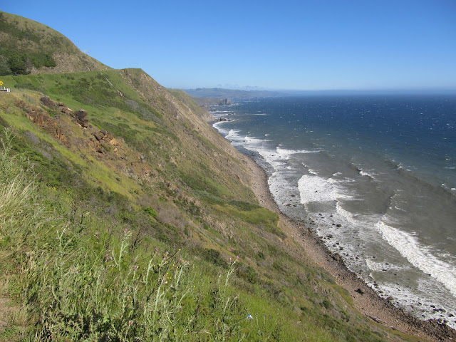
The view from a stretch on Highway 1

That ocean mist stuck to my helmet shield

There is a lot of construction on the highway but nothing big

Once you leave the coast you get into the forest. Great fun and very challenging road


This Red Wood tree has 2400 years.


I had to pay $3 bucks to do this. $5 for cars


This is on RT 101 North beautiful road


I was pumping gas in Weaverville and this is the view from the town. Soon I would be passing by other snow covered peaks.


First wave of a bug storm while riding through miles and miles of rice paddies

Second wave.

My pants!
This was today's route to Alturas,CA


View Larger Map

Thursday, May 19, 2011

Time to Return Home

Today, I suddenly changed my mind. I was planing to leave Thursday, May 19 but it seems that I have to be back home earlier than I thought. For some reason, I am felling with a sense of accomplishment even when I have to do half of the trip back home. In my mind, I feel I am done and now I have to go back home.
The day looked mostly cloudy early in the morning but then it started to clear up. The sun started to show timidly on the window and that gave me confidence that the day was going to be clear. After doing my laundry, I picked up my things and say goodbye to Russ and Tina.

The plan is to go along the coast on route 1 and turn East in Eureka, CA. I crossed the famous Golden Gate bridge, stopped for the official picture and continue North to get on to route 1.

What a ride route 1 is!!! A narrow two lane road which I found very challenging. There is no time for distraction on this road. The turns are super sharp and steep. 25 miles per hour is the speed to manage this curves. Faster can put you across the yellow line. The wind was strong and cold. The mist from the ocean on my visor.

After 200 miles of riding, I stopped in Little River, CA just a few miles from Mendocino. Tomorrow, I plan to start the day early and make some progress. I don't know where I will finish the day .

My first stop in San Francisco


The wind coming from the ocean was strong and cold.


Highway 1 is challenging with very sharp and steep curves


My Chromehead brother Dennis. We met coincidentally while I was taking pictures in Bodega Bay, Salmon Creek Beach


Today's route


View Larger Map

Wednesday, May 18, 2011

A day in California

Yesterday, I spent the day with my host Russ riding around Palo Alto, Highway 1 and into the Big Basin RedWoods State Park. What a great place to ride in a motorcycle! Unfortunately for us the weather did not cooperate and we were doing the tour by car. It was raining and it was cold and windy.
No doubt this part of California is amazing, I was surprised by the all the flowers along the coast.
Today, I am getting my things ready to start my journey back home to NJ. I am looking forward Yellow Stone National Park, Mount Rushmore and who knows what else along the way.
Today, it's going to be Highway 1 all day. I am not going to be disappointed. You can count on that.

After 14 days on the road. I am finally on the West coast.


This is just a sample of the flowers along the coast of California. I had never seen flowers on the coast

This park has some massive trees. Most of them are more than a thousand years old.

These are some of the little trees in the park.

That's why I hang out with guys bigger than me. So I can look smaller.

I wish it was sunny but I had to settle for this view.

Dinner with Tina and Russ. Salmon was delish.
This is today's route. Sun is coming out and the weather drying up. It should be fun.


View Larger Map

Tuesday, May 17, 2011

May Monday 16 20011, I arrived in Mountain, California

Victory!! after many days on the road , I finally made it to California thus completing one half of my journey through the United States.

I am glad I left Las Vegas with cool temperatures, 50 degrees, and calm winds. It looks like that desert gets mighty hot in the summer.
On Sunday, the winds were at 40 miles per hour but I was in the comfort of my hotel glad that I had to stay for the day.

Monday morning 7:00 AM, I had to put my winter clothes again. The plan for the trip to California changed suddenly the morning of May 16. I wanted to go North along the Nevada- California border and then across the Sierras through Inyo National Forest and the Yosemite. The weather was not cooperating and they had snow up in the Sierra. I didn't want to risk it as RT-120 is seasonally closed.
I opted for I-15 W then I-5 North along the Sacramento Valley. There is nothing to see in this part of the country. Just orchards, vineyards and farms for as long as the eye can see.
I was riding mainly under cool weather but after climbing the mountains it got too cold for comfort, the clouds covered the sun and the wind picked up speed. By 4:00 PM, it started to rain and I won't be out of it until I got to Cupertino at around 5:30 PM. At 6:00 PM, I was knocking on the door of my Cromehead brother Pencin, who generously offered me room and board. Tuesday May 17, I will enjoy his hospitality and YES, another lecture on his favourite subject, Final Drives.

Crossing the state line to California

As you can see, these mountains are little boring in California

The overcast sky made it colder and uncomfortable. The wind getting stronger.


The trip. This map only shows where I have being but not the exact route. I will be posting from now on two maps: a general map showing my location and a smaller one with the exact route of the day.


View Larger Map

Vegas Baby!

Last Friday, I could not find a room in the town of Flagstaff so I moved 10 miles West to Bellmont where I found a confy room to spend the night.
The next day after a good night sleep, I got ready to travel to Las Vegas, Nevada and cross another time zone. I filled my tank with gas and started my trip at 9:15 AM at 11:08 AM I was filling my tank again after 137 miles in the town of Kingman.
I took I-40 all the way to Vegas. Most of Arizona was nice and the temperature was cool. I was riding along very high mountains and high desert but once I started to descend and getting closer to the Nevada border the temperature started to climb. When I got to Kingman, Arizona I removed my jacket liner. It was hot and the sun high.
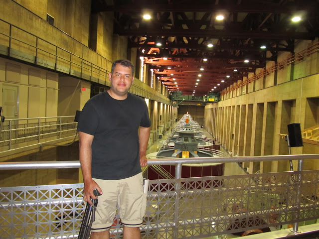
I continued to Las Vegas with a stop at the Hoover Damn. Took pictures and a tour of the power plant.
After a couple of hours touring the Damn, I arrived in Vegas with just 245 miles on the clock. I am going to take Sunday May 15th off and Monday continue my trip to California.


Of course, the official photo for Nevada.
Temperatures started to rise. I had to remove my jacket liner and adapt the pants for hot weather.

The view in Arizona and Nevada for miles ahead

This 50 feet in diameter pipe takes water to the turbines. The vibration is enormous.

Taking a tour of the generating plant

Sunday, May 15, 2011

Towards The Grand Canyon


I woke up early Friday morning. The night before I had the chance to do my laundry. It seems that a lot of the Motel 8 have this service. It felt good to have everything clean again. I was down to my last underwear. 
It was a cold morning with 51 degrees of temperature. The sky was clear and I had my tank full with gas. At 9:00 AM sharp, I was heading West again.
The plan that day was to arrive to Flaggstaff, AR and while at it, see the Four Corners and the Grand Canyon.
Most of the morning, I was riding through Navajo territory. It was beautiful desert with snow covered peaks in the horizon. The cold weather was a great help for me and for my C. We were both riding comfortably.
I was fuelling my C every time I could. I was passing by some very deserted land with no end in sight and I didn't want to get stranded for lack of gasoline. I was pumping gas every 60 to 70 miles in average. I told you I got compulsive about it.
The first stop was the Four Corners. I took 64 W to get there passing Farmington and Shiprock. The Four Points is the only part of the USA where 4 states come together at one place. Arizona, New Mexico, Utah and Colorado and for $4 dollars you can see it all. There I bought some trinkets.... I mean jewellery from the Navajo Indians, took pictures and started my journey again towards the Grand Canyon along RT 160.
For 4 hours, I rode through the desert and the temperature started to get hotter but not to the point where I was sweating . As I got closer to the Grand Canyon, I started to ascend higher and higher. The views more dramatic than before. There are a lot of trading posts along the road to the Canyon and I stopped by a few to see the merchandise. $12 for a bag of Beef Jerky!!?, I don't think so.
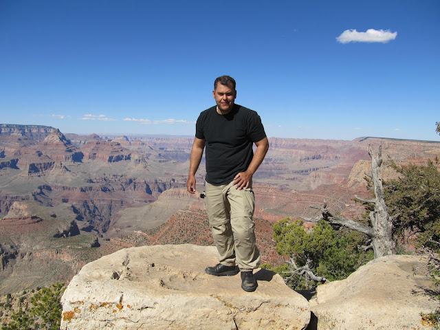
I arrived at the entrance of the park, paid $12 (for motorcycle) and continued forward at altitudes above 7,000 feet. The plan was to stay a few minutes in the Canyon, take a picture and move on to Flagstaff which was almost 1.5 hours away, but the plan backfired. The magnitude of this canyon takes a long time to absorb. As you go along different observation points the canyon change its colours and shades. It is something that you have to sit down and enjoy little by little and I did. I wind up staying 3 hours riding along the canyon through some very old trees and passing by “Puma in the next 2 miles” signs. I spent most of time at the aptly named “Grand View” overlook.
When the clock almost hit 6 o'clock, I put some more gas at the entrance of the park and moved on to Flagstaff, Arizona. What a beautiful little town Flagstaff is surrounded by a national forest and snowed covered peaks.
I couldn't find a room in town. It was graduation day for Northern Arizona University. It was almost 8:00 PM and I had to push forward, to the outskirts of town to find a room. I found a Motel 6, which I promised I will never use again, but this one looked new and it was.
Tired from a long day, it was time to relax a little, take a shower and wait for the next day comfortably in the arms of Morpheus. Las Vegas, Nevada was next!

Official photo of my entrance to Arizona

I am usually crossing one state at the time, but this time I was in 4 states at the same time.
The cruise control came handy when I had top cross the Arizona desert .

On the road towards the Grand Canyon in Arizona. temperatures started to climb here but it was comfortable still.
Grand Canyon


These are the San Francisco Peaks near Flagstaff, Arizona. Considered sacred by the Hopi Indians. Home of the Cachina people and the Navajo's Sacred Mountain of the West. The road I was travelling RT 160 got me very near just on my right hand side.
This was the route of the day.

View Larger Map